Skip to Content
  •  
  • Contact Us
GEOSIGMOID GROUP
  • Subsurface Studies

    Geological & Structural Modeling

    3D structural frameworks

    Reservoir Engineering & Simulation

    Performance and recovery

    Seismic Interpretation (2D, 3D & 4D)

    Imaging the subsurface

    Forecasting & Field Development Plans

    Scenarios and forecasts

    Rock Physics & Seismic Inversion 

    Seismic to reservoir properties

    Resource & Reserve Evaluation 

    Volumes, risks, economics

    Reservoir Characterization

    Petrophysics and reservoir quality

    Geomechanics & Well Stability

    Stresses and wellbore integrity

    Subsurface Studies

    Integrated subsurface studies, from geology to reservoir engineering.

    Explore Subsurface Studies
  • Field Operations

    Rig Inspection & Acceptance

    Compliance and readiness

    Logistics & Field Readiness

    Mobilization and logistics

    Rig Refurbishment & Recommissioning

    Back to safe operation

    Maintenance Planning & CMMS Setup

    Maintenance and CMMS

    Equipment Inspection & Certification

    Critical equipment checks

    HSE Management & Field Compliance

    Safety and compliance

    Drilling & Workover Operations Support

    Technical operations support

    Operational Audits & Troubleshooting

    Audits and performance

    Wellsite Supervision & Company Man

    On-site supervision

    Crew Training & On-the-Job Coaching

    Competent field crews

    Field Operations

    Independent supervision and practical field support, from rig acceptance to HSE.

    Explore Field Operations
  • Software Development
    EraFlow

    EraFlow™

    17 modules, 54 plug-ins

    GeoScan™

    Geoscience data management

    AI & Advanced Subsurface Analytics

    AI/ML for E&P workflows

    Subsurface Digital Platforms & Engineering Software

    Custom platforms and digital twins

    Software Development

    Proprietary platforms and custom software for the subsurface.

    Explore Software Development
  • Training

    Geology

    Petroleum geology and interpretation

    Production Engineering

    Well and field performance

    Geophysics

    Seismic and inversion workflows

    Drilling

    Well design and performance

    Petrophysics & Reservoir Modeling

    Static modeling and properties

    Digital & AI Subsurface Geoscience

    AI-driven geoscience

    Reservoir Engineering

    Reserves, simulation, optimization

    Multi-Disciplinary Courses

    Customized programs

    Training

    Applied geoscience and engineering courses for industry professionals.

    Explore Training
GEOSIGMOID GROUP
      • Subsurface Studies
      • Field Operations
      • Software Development
      • Training
    •  
    • Contact Us

    Subsurface Studies

    Reservoir Characterization

    Define reservoir properties from geological, geophysical, and petrophysical data.
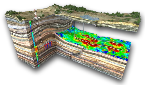
    Reservoir Characterization - illustration

    Petrophysical Analysis

    Derive porosity, saturation, and lithology from well logs.

    Facies Modeling

    Map rock types and their distribution in the reservoir.

    Static Reservoir Modeling

    Build integrated 3D reservoir models.

    Decision Support

    Quantify volumes and uncertainty for development planning.

    Core Features

    • Data Integration

      Integration of well logs, core data, seismic interpretation, inversion products, and geological inputs into a unified reservoir framework.

    • Petrophysical Evaluation

      Log QC, lithology interpretation, porosity, saturation, net pay, and rock typing.

    • Facies Analysis

      Facies identification from cores, logs, and seismic attributes; depositional environment interpretation.

    • Static Reservoir Modeling

      3D reservoir models integrating structure, facies, and petrophysical properties.

    • Property Modeling

      Distribution of porosity, permeability, saturation, and net-to-gross using geostatistical methods.

    • Uncertainty & Risk Assessment

      Scenario-based modeling and uncertainty quantification for reservoir volumes and connectivity.

    • Integration with Seismic Inversion Results

      Improved reservoir models driven by seismic inversion data.

    Foundation Package

    • Data Inventory & QC

      Review and quality control of well logs, core data, seismic interpretation, and petrophysical inputs.

    • Petrophysical Modeling

      Consistent petrophysical interpretation and upscaling for static modeling.

    • Facies Modeling

      Facies modeling using deterministic and stochastic approaches.

    • Volumetrics

      STOIIP / GIIP estimation with uncertainty ranges and scenario comparison.

    • Report & Knowledge Transfer

      Technical report documenting methodology, assumptions, results and uncertainties, reviewed with your team. How we work →

    FAQ

    Frequently asked questions

    Clear and concise answers to common questions about our reservoir characterization services, integrating geological, geophysical, and petrophysical data to reduce subsurface uncertainty.

    Ask our team

    We deliver integrated reservoir characterization combining seismic interpretation, rock physics, petrophysical analysis, and geological modeling to define reservoir properties and heterogeneity.

     Typical inputs include seismic data, well logs, core data, production data, and existing geological models. Data QC and integration are performed as part of the workflow.

     Our workflows improve understanding of reservoir geometry, properties, and connectivity, supporting volumetric calculations, reserves estimation, and optimized field development planning.

    Yes. Our results are fully compatible with reservoir simulation models and Field Development Plans (FDP), ensuring consistency across subsurface disciplines. 

    Deliverables include reservoir property models, facies and petrophysical distributions, uncertainty assessment, static models ready for simulation, and a comprehensive technical report.

    20+ integrated reservoir characterization studies

    Multi-disciplinary integration (geology, petrophysics, seismic, engineering)

    Static models optimized for dynamic simulation and uncertainty analysis

    Contact us

    GEOSIGMOID GROUP

    We turn subsurface data into decision-ready intelligence - consulting, field operations, software and training for exploration, development and production.

    Talk to our team →

    Services

    • Subsurface studies
    • Field operations
    • Software development
    • Training

    Platforms

    • EraFlow™
    • GeoScan™

    Company

    • Our origins
    • Contact us

    Offices

    Registered office - Dubai

    GEOSIGMOID GROUP - FZCO

    • Premises DSO-IFZA, IFZA Properties, Dubai Silicon Oasis, Dubai, United Arab Emirates
    • +971 50 890 5982
    • contact@geosigmoid.group

    Office - Tunis

    • IQ Smart Building & Business Center, Space Offices 807, Tunis, Tunisia
    Copyright © 2026 GEOSIGMOID GROUP

    We use cookies to provide you a better user experience on this website. Cookie Policy

    Only essentials I agree